|
Some observations:
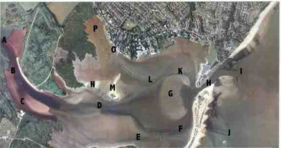
A. Christchurch Sailing Club deep water Moorings, this river leads to the splitting into the R. Stour and Avon at the Sailing
Club and Priory.
B. Visitors moorings. as mentioned in almanac, these are a few white buoys near the reeds, it is neccesary to use a tender to
land from these as it is quarter mile upriver to reach civilisation (CSC)
C Sailing Centre for dinghies etc (council run/owned exclusively for courses)
D. Narrow and Shallowest part of the buoyed (in Summer) channel, from christchurch to the open sea. If you get stuck here, you
wont be the first or last.
E. Narrow Channel suitable for anchoring/picnics. note the faint ESE-WNW line that goes from 'F', thru 'E' and a bit further. If
you go from E to D, you will find the depth reduces about 2 feet, so always reverse back up the channel to get out, unless you have a rising tide and take it slowly to minimise sticking in the muddy sand.
F. the 'trots' are deep water sheltered moorings let by the council and water company. the buoyed channel is to the North of the
line of moorings. the buoyed channel passes the ferry jetty near 'F' which may not be used for landing(it says). To proceed out to sea, follow the shore at least 20 feet to starboard, watching depth
sounder and keeping green cans 20 feet to the left so oncoming traffic can pass. Your approach to the run 'H' must be angular, not curved at the turn, to leave the shallow rubble on the starboard side
well clear.
G. The sand bar
you could all play cricket here twice a day, but it looks invitingly clear of boats! mind you it's only sand, and good fun if
you want to 'land on an island!' for fun. about .
As you can see on the phot, it is about 300 yards long and 150 wide. at HW springs in fact it is under over 0.5m / 2'4" water,
as I sailed over it then a few times just to prove it can be done.(actually 1 hour before 2nd HW for safety in case I got stuck). On the Western and South sides are several yellow spherical buoys
which announce the underwater edge of the bar, and on the Eastern side is the channel buoys and unmistakable moorings of fishing boats as a guide.The Northern side is covered on 'E' above.The West, East
and South sides go up at about 10 degrees so you get plenty of warning if you wandered past their buoys, but the North side is steeper, and more cluttered.
H. The 'run' -Continuing out, down the run, which is approx 3 knots spring ebb, it is best to keep well away from the shallow
Southern side to starboard by leaving the quay wall and tied up boats say 30 feet to port. beware kids, jetskis and canoes here. The chop in the run can be quite vigorous up to 4 feet peak-trough
with the tide colliding 2hours before LW and force 3 winds or above. following the buoyed channel (summer) the sand bar is visible to starboard by breaking surf and seagulls. the depth can be as low as
1.0m here at LW, and this is the channel!
if there are no buoys here, you will have to use the leading light on the quay wall as a guide (see almanac), also rely on the
depth guage to ensure you dont proceed onto the bar. usually the prevailing SW wind is about 20 deg stbd so you are crashing over the shallow waves for about a hundred feet, with the bar passing to stbd
at its closest about 50 feet.
I. Outer Entrance buoys.(N50,43.476/W1,43.927)
red and green with reflective tapes. about 4 feet tall. This is your most important GPS waypoint!
J. Clarendon Rocks (N50,43.160/W1,44.280)
In fact the mostly submerged remains of an abandoned Victorian pier that go out into the Bay.
Just North of here, half-way between I-J would be, I planned once, a good place to anchor in case you had to wait for the tide
to come in before entering the harbour (when I returned from Cherbourg at dusk), there should be some signifficant shelter from prevailing SW winds, good sandy holding, close to land in emergency, and
within a few hundred yards of the entrance and spit to allow good observations. (N50,43.350/W1,44.100)
K. the narrow channel North of the harbour sand bank.
waypoint N50,43.477/W1,44.744 is about half way between dirty buoy and the Mudeford quay slipway and lifeboat station. In
daylight proceeding around the Northern end of the sandbar, you will notice a circumference of moorings going around. depending on which way the tide is swinging these boats, you can pass to the North of
them less than 50 feet. A strong current from Stanpit carves this channel deeper, but beware mooring tackle in this area is a minefield; RSJs, Ships anchors with protruding flukes, engine blocks etc! so
keep the revs low, or sail through. nice short cut, but safer to go round the bar to the South.
L. The 'Dirty Buoy' (N 50,43.433/W1,44.948) as i call it, actually about 2 foot diameter, covered in seagull poo! This
marks the junction of the North harbour areas; from here to Strides moorings 'O' and Stanpit 'P', also to the main channel(running between 'D' and 'F'), also to the narrow channel 'K'
If you want to get from the main channel to the dirty buoy or Stanpit, turn North from the main channel(D-F) at about W1,44.884,
where one of the green channel buopys has a taller triangular top than the others. Near the dirty buoy, turn NW for Stanpit keeping the moorings to port by about 30 feet . If you cant find the dirty buoy
at night, there is a tall house with a long flat roof behind, usually lit up like a christmas tree (in fact the reason you cant see the grey buoy at night!)
M. Blackberry Island
a bird sanctuary, please dont land as there are nesting seabirds in the shallow weed. it is shallow but passable between the
island and Stanpit marsh to the NW for some shallow vessels. The island (sometimes completely submerged at HAT) is surrounded by gently sloping sands which fall 0.5m approx 75 yds from the Western shore
of it.
N. another little drying mud - spit you need to keep clear of
O. Strides Jetty and slipway.
This family moorings and lobster business has been in Mudeford (N.Harbour) for generations, and is a good place to tangle your
prop as they leave some of the submerged moorings trailing floating rope in the winter. The soundings are 0.1m shallower at the jetty area than 50 yards SE, and 0.1m shallower past the jetty NW toward
stanpit.
A useful guage (if it doesnt move)
I found is the car tyre slung on the end of the galvanised jetty end (sailing club's), which touches the water exactly when the shallowest part of the route out to sea is 2feet4inches deep (being half way between dirty buoy and the main channel)
so if you are anchored at Strides, and draw 3 feet, and the tyre is 6 inches above the water, though you will be floating, you
will ground just after or before the dirty buoy. In fact, a 3 foot draft boat is generally stuck here unless HW springs+-2hr.
P. Stanpit
council/water company moorings, so you can make your own mooring for an annual charge, or anchor here. a pretty spot amongst the
reeds and wildlife, no jetskis or traffic, unlike most of the harbour, so worth a visit if you draw less than 2'6". in the North corner is a small green leading 50foot to the main road, leading to local
convenience stores 400yds either way and bus stops.
the water is so shallow here, you can safely wade to the shore in waders most times. who needs a tender? anyway the locals on
the North shore are a
|