|
|
|||||||||||||
 |
|
|
Welcome to the Christchurch Harbour Website, created by an amateur with possibly too much time on his hands, and a lot of skill and interest.
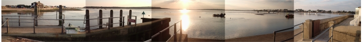
My hope is that the information here may be of such use as to prevent boat users from getting stuck on the sand (/mud), coming to grief in the run (harbour entrance) or picking a shallow spot to anchor or navigate in. 10 August 2009 updated GPS position for between outer buoys = 50 43.364 N, 1 44.062 W (this is the position to aim for if you are coming into Christchurch from the South) 11 MAY 2008, i have updated GPS positions for all buoy pairs in the entrance and harbour to get you in, see passages page. Vessels with draft below 3 foot should only enter on HW or not at all. I dont think it is possible to get 5 foot in, ever. One day i will work out the min depth on the route into CSC and corrections for tidal range, pressure, wind etc? Look on the 'Passages' Page. There's a nice panorama of the shingle bank at LAT on the panoramas page. Luckily there is a lifeboat just inside the harbour, but at low tide they need their tractor to tow it over the mud. IF you have a shallow draft (<2'6") boat, this is a must see, from a nature point of view, for the swans and dinghy racing, and there is no heavy shipping or gin palaces zooming round dangerously to avoid (NE Poole harbour and entrance is horrible - but S Brownsea Is. fantastic).It might be possible to admit over 4 foot draft on spring high but i wouldnt try it.
if you have any surprising or universally interesting reports, such as { static tide guages, things you can see in the harbour that tell you the tide height reliably getting a boat more than 4 foot draft in, the harbour, upriver, (incl how you measured the draft exactly, and time/date etc) calculating the affects on the predicted tide heights by pressure/wind etc, }please email me at the bottom of page.
Contrastingly, there is little 'official' detailed information out there in almanacs, charts or other that will give anyone with a heavier craft little peace of mind, or hope of exploring the majority of the harbour in their lifetime. So here it is, my personal survey, with collected local information and contributions, that should bring to life
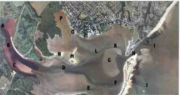
the relatively unexplored harbour places. above: The Aerial Photos section includes a thorough guide around the main harbour channels, hazards and attractions The Passages section uses this to illustrate and navigate you using dozens of accurate GPS WAYPOINTS
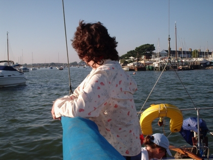
above: Looking toward Stanpit from the North channel on Strides shallow moorings
DISCLAIMER: there had to be one of these! - this information is provided purely for interest , and should not be used as a basis for navigation. always refer to up to date charts, tide tables and almanac before entering this shallow harbour. I do not accept any liability for the accuracy of the information provided. Nick Le Feuvre B.Eng Maritime Technology, Southampton Institue 1997,+ 2 years B.sc Nautical Studies Plymouth University majoring in Navigation, Chartwork & Hydrography 1987 contact me on 01202 470184, email nick@REMOVETHISworldsbestloudspeakers.com (click to get correct address ) www.worldsbestloudspeakers.com check out my other great sites at www.greatlinks.co.uk |
|
|
[Christchurch Pilot] [Aeriel Photo] [Passages] [GPS Plotting] [OS map] [Panoramas] [Photos] [Yacht Racing] [Links] [GPS 2008] |