|
|
|||||||||||||
 |
|||||||||
 |
 |
||||||||
 |
 |
||||||||
|
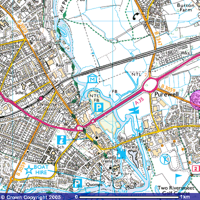
Reproduced from Ordnance Survey of Northern Ireland mapping with the permission of the Director and Chief Executive, © Crown Copyright. http://www.get-a-map.co.uk/getamap/ The reason i like this, is it actually shows a lot more than the admiralty and other brands charts do. The next best map was in silk cut almanac, but that was just a sketch based on this by the look of it. Note the dotted lines in the harbour are actually showing the dredged buoyed channel, and lots of other Points of interest like road access to stanpit, location of priory, and MHW which is a lot more visual that LAT of marine charts. I keep a photocopy of this on the boat for reference. The OS told me that this hydrographically was probably based on an infrared aircraft photo from the 1950s?? |
|||||||||
|
[Christchurch Pilot] [Aeriel Photo] [Passages] [GPS Plotting] [OS map] [Panoramas] [Photos] [Yacht Racing] [Links] [GPS 2008] |