|
|
|||||||||||||
 |
|
|
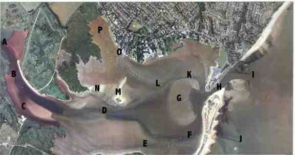
1. Passage from Christchurch Bay to Christchurch Sailing Club (town centre)[mapIHFDBA] 2. Passage from Dirty Buoy to the Run[mapLKH] 3. Rocks and misc 4. Passage from Christchurch to Cherbourg
1. Passage from Christchurch Bay to Christchurch Sailing Club (town centre) speed limit is 4 knots ANYWHERE INSIDE THE HARBOUR (RIB PATROLS ENFORCE THIS) Other waypoints within the entrance channel as buoyed Summer 2006 are from my Diff-corrected-GPS; approx centres of channel +/-5metres.. Obviously you need to keep to the rules of the road; passing stabd of anything coming toward you.within the channel The channel is at least 10m wide! IT WILL TAKE YOU 20 MINUTES @MAX SPEED (4 KNOTS) TO GET TO THE CSC MOORINGS, ANOTHER 10 TO GET TO POINT 'A' . IT WILL TAKE ABOUT 6 HOURS IF YOU GET STUCK ON THE MUD, SO AVOID GOING INTO IT HARD. fixes from GPS (Garmin GPS72) May11 2008 (corrected 7/7/8) , exactly imbetween red/green lanes (i disclaim all responsibility for innacuracy of course, ) BEGIN 18:37HRS TRAVELLING EXACTLY 4 KNOTS sog
N 50 43 438, W 1 44.210 First Entrance Buoys pair depth 2.2m (time was 2nd high exactly) N 50 43 457, W 1 44.276, 3.1m N 50 43.473, W 1 44.354, 2.2m AT THIS POINT YOU TURN PORT AND AIM UP THE CHANNEL. THE SHINGLE BAR IS ABOUT 6 FOOT SOUTHWEST OF THIS BUOY, BUT ITS STEEP SO EVEN IF YOU CAN SEE THE SHINGLE THROUGH THE WATER (UP TO ABOUT 6 FEET ON A CALM DAY), ITS NOT UNUSUAL. WORST POINT HERE IS WIND OVER TIDE, IT GETS QUITE ROUGH FOR THE NEXT 100 YDS (HAVE SEEN HEIGHTS OF 4 FOOT) YOU WILL NEED TO SPLIT THE DIFFERENCE BETWEEN THE SHORE AND THE BUOY AND DRIVE APPROX HALF WAY BETWEEN, SO OUTGOING VESSELS CAN SAFELY PASS YOU ALONG YOUR PORT SIDE, BUT DONT GO CLOSER THAN HALFWAY AS THE TOURISTS FISHING TACKLE IS OFTEN IN THE WAY AND IF YOU GET CAUGHT ITS A LEE SHORE. CHANCES ARE ALSO, YOU CANNOT SAIL IN NOW AS THE WIND FUNNELS OUT THE HARBOUR, SO YOU HAVE TO HAVE ENGINE ON. IF ITS CHOPPY, I ALWAYS HAVE MAINSAIL UP FOR STEADYING, BUT YOULL NEED TO FURL THE JIB. THE IMPORTANT THING TO NOTE HERE, IS THAT THE ENTRANCE MINIMUM IS ABOUT 20CM DEEPER THAN THE SILT UP RIVER HALF A MILE, SO UNLESS YOU HAVE 20+CM CLEARANCE COMING IN, YOULL GET STUCK GOING WEST WITHIN THE HARBOUR BETWEEN THE MOORINGS. N 50 43.386, W 1 44.579, 3.2m N 50 43.325, W 1 44.600, 3.4m THIS IS IMPORTANT, DONT CUT THIS CORNER - TURNING TO PORT TOO EARLY YOU NEED TO COME IN WITHIN 10M OF THIS BUOY OR 3.4m WILL BE MORE LIKE 1m HALFWAY TO SHORE THE FERRIES OPERATE NEAR THIS POINT BUT THEY ARE MANOUVERABLE. N 50 43.249, W 1 44.601, 3.2m GO ALONG THE ROUTE SLOWLY AS THERE ARE SWIMMERS AND CANOES FROM THE BEACH HUTS, AS WELL AS THE FERRY N 50 43.208, W 1 44.626, 2.3m TURN TO STARBOARD FAIRLY SHARP, ALLOWING ROOM FOR THE FERRY TO TURN ON ITS PIER NEARBY N 50 43.196, W 1 44.695, 2.2m KEEP WITHIN THE CHANNEL, STARBOARD OF THE GREEN BUOYS IS A HUGE DRYING SANDBAR N 50 43.187, W 1 44.803, 2.4m N 50 43.185, W 1 44.924, 2.3m N 50 43.198, W 1 44.985, 2.3m N 50 43.235, W 1 45.025, 1.9m OBVIOUSLY THE CRITICAL POINT, SHALLOWEST EN ROUTE, MY IDEA, IF ITS COMPLETELY CLEAR OF TRAFFIC AND WINDY FROM THE SOUTH, KEEP TO MIDDLE OR PORT OF CHANNEL IN CASE YOU GROUND, SO YOU WONT DRIFT INTO SHALLOWER WATER. N 50 43.271, W 1 45.080, 1.9m N 50 43.298, W 1 45.220, 2.0m N 50 43.322, W 1 45.362, 2.0m (typing error corrected on 7/7/8) N 50 43.322, W 1 45.455, NO RECORD, PROB 2M N 50 43.315, W 1 45.528, NO RECORD, PROB 2M N 50 43.309, W 1 45.604, NO RECORD, PROB 2M N 50 43.321, W 1 45.679, 2.0m HERE THER IS NO GREEN BUOY, JUST THE RED ONE AND THE SHORE N 50 43.350, W 1 45.781, 2.0m ITS SLIGHTLY DEEPER NEAR SHORE SIDE OF MIDDLE N 50 43.395, W 1 45.903, 2.0m N 50 43.457, W 1 45.989, 2.6m LAST BUOY DONT GO TOWARDS NORTH ITS A LEE SHORE AND SHALLOW MUD (NO BOATS MOORED) END 18:59 HRS , SO THIS SECTION TOOK 20 MINUTES NOW YOU ARE IN THE RIVER WHICH IS MOORED EITHER SIDE, SO SIMPLY DRIVE UP THE STBD SIDE OF THE RIVER, TIDE CAN BE QUITE FIERCE HERE AT FULL EBB SPRINGS SAY 4 KNOTS (ABOUT THE FASTEST TIDE IN THE HARBOUR EXCEPT THE ENTRANCE 'RUN') AS YOU GET PAST THE REEDS ON THE STBD SIDE, DO NOT CUT THE CORNER, KEEP THE GREEN BUOY TO YOUR STBD SIDE, AS THERE IS A MUD BANK BETWEEN IT AND THE REEDS (CHANNEL ONLY 20M WIDE HERE BETWEEN MOORED BOATS AND THE GREEN BUOYS) FURTHER UP YOU WILL SEE A SPLIT AS THE STOUR GOES WEST TO PORT, AND THE AVON RUNS IN FROM STARBOARD, AGAIN IF YOU WANT THE AVON, DONT CUT THE CORNER, BUT TRAVEL WITHIN 30M OF THE SHORE BEFORE TURNING OR WATCH YOUR DEPTH GAUGE AND GO SLOW
fixes from GPS (Garmin GPS72) May1 2006, exactly imbetween red/green lanes (i disclaim all responsibility for innacuracy of course, )
50 43 482, 1 43 755 First Entrance Buoys pair 50 43 534, 1 43 855 50 43 551, 1 43 939 50 43 540, 1 44 051 50 43 542, 1 44 146up the main 'run' narrow&deep water about 2-3knots spring ebb. 50 43 539, 1 44 292 50 43 551, 1 43 939 (avoid submerged rubble extending 70ft radius from S end wall nr. black house) (do not cut corner around black house, keep max 70ft from NW quay until past the end of the quay into the harbour THEN turn S) 50 43 387, 1 44 581 CAFE on East bank with toilets and water. dont anchor in the channel. 50 43 250, 1 44 601 50 43 214, 1 44 269 sharp bend near jetty around harbour sand bar SE corner 50 43 201, 1 44 673 no red buoy, keep council moorings to port 50 43 193, 1 44 788 depth approx 3-6m 50 43 188, 1 44 919 safely past the sand bar 50 43 197, 1 44 979 if you were going to Stanpit passage, turn off from the main channel here NNE keeping yellow buoy Stbd 50 43 253, 1 45 040 this is about the shallowest point with the next two points, coming in. 50 43 279, 1 45 092 I am told that the spit bar is shallower than here.(about 2 ft dry at LAT) 50 43 306, 1 45 258 50 43 327, 1 45 360 50 43 322, 1 45 459 50 43 313, 1 45 552 50 43 310, 1 45 616 50 43 319, 1 45 668 50 43 351, 1 45 778 if there is no Green buoy, it's assumed 20 foot from the NE shore(stanpit nature reserve) 50 43 394, 1 45 903 the NE shingle bank is steep and easy to land on with the tide rising. just opposite to the West, you will find the 3? visitors moorings buoys. They are near the reeds approx 50 43 590, 1 46 185?. the idea seems to be to use your tender/dinghy to get ashore by going upstream for 1/4 mile to slipways near the bandstand. There are often hooligans and thiefs in the Summer esp, so lock it or lose it. Affiliated members only can call at CSC (tel 01202 483150).This visitors buoy- moorings dont dry out and as far as i know they are foc. 50 43 507, 1 46 037 make sure you dont get blown to the NE with the tide falling as it is a shallow muddy elbow you can stand up in mostly. that's it, now you are between the reeds and the CSC mooring lines, keep right (of way). there is another green buoy or two just as you see the buildings ahead keep them on stbd of course coming in as they mark shallow muddy bends NE
SUMMER 2004 (obsolete but preserved for anyone who is interested in the shifting channel/bar) N50,43.476/W1,43.927 (Outer Entrance buoys - 'I') N50,43.507/W1,44.001 N50,43.527/W1,44.087 N50,43.535/W1,44.156 (this is approx shallowest part so wind up keels at LW!) N50,43.526/W1,44.272 (start motor and drop sails in SW wind here?) N50,43.497/W1,44.370 N50,43.464/W1,44.415 N50,43.429/W1,44.479 N50,43.400/W1,44.537 (end of the quay/run - 'H') N50,43.386/W1,44.562 (avoid submerged rubble on SW corner of run if traffic allows) N50,43.349/W1,44.590 (going South and between sand bar and beach huts) N50,43.304/W1,44.602 (near fishing/ferry boat moorings) N50,43.263/W1,44.607 N50,43.227/W1,44.618 (near ferry jetty) N50,43.222/W1,44.622 (round the corner -'F') N50,43.206/W1,44.650 (turn slightly again) N50,43.194/W1,44.717 (South of sand bar) N50,43.186/W1,44.822 (SW corner of sand bar) N50,43.190/W1,44.934 (ideal part of the channel to go North to dirty buoy from) N50,43.195/W1,44.968 (turn towards NW avoiding hengistbury mud bank) N50,43.270/W1,45.068 (turning W avoiding Blackberry Island(protected bird nests)) N50,43.314/W1,45.310 ('D' past Blackberry; NOTE short cut to 'O' possible but risky as it was 0.6-0.8m at HW springs - directly North from here between the shallow islands. Dont attempt after high water!) N50,43.331/W1,45.392 (narrow dredged channel here) N50,43.309/W1,45.565 N50,43.312/W1,45.628 N50,43.344/W1,45.766 (passing South of Stanpit marsh/nature reserve) N50,43.429/W1,45.944 N50,43.615/W1,46.097 (passing NE of hengistbury head corner -'B') N50,43.698/W1,46.309 (going between the reed bed moorings either side towards CSC -'A') N50,43.798/W1,46.396 (passing W of muddy shallows on reed bed corner) N50,43.813/W1,46.408 (CSC visitors pontoon) END
2. Passage from Dirty Buoy to Run N50,43.478/W1,44.847 (small craft moorings) N50,43.472/W1,44.787 (imbetween the deeper moorings N of bank) N50,43.478/W1,44.729 N50,43.478/W1,44.675 (adjacent trawler moorings) N50,43.457/W1,44.626 (passing East of bank, West of quay ) N50,43.418/W1,44.608 (begin turn into run) N50,43.392/W1,44.551 (SW end of run) END 3. Rocks and misc. while you are entering positions, here are some vital ones ROCKS N50,42.580/W1,44.815 Beerpan Rocks, big drying shoal South of Hengistbury Head Groyne N50,43.160/W1,44.280 Yarranton Rocks, submerged pier foundations near beachhuts in bay N50,43.5/W1,43.5 Rock near Christchurch entrance (LAT over 4m deep?)
N50,37.1/W1,39 Whisper Fairfay light on West of Needles hazardous area
N50,46.630/W1,50.470 'BIA' RDF station at Bournemouth Airport N50,41.171/W1,55.930 East Looe Buoy, Poole entrance N50,41.015/W1,56.474 Inshore channel, Poole entrance
4. Passage from Christchurch to Cherbourg Everyone believes that you just sail due South, and 12 hours later the tide has come in and back, so you ignore it's effect. this is not safe enough, as in moderate winds, the overfalls in mid-channel are very rough as I found out (F5 10 foot waves), so you should plan to avoid them. my yacht travelling about 5knots took 12 hours (63 nm), the Alderney race to Cherbourg's West is so deadly(>7knots), that you should prefer to approach Cherbourg from East end of its long breakwater. The worst risk is to arrive at the Western breakwater LW-3hr, as you will be swept westwards with a Spring tide towards the race, falling daylight?, tired crew?, falling wind?, engine problems?. Cherbourg is great port, open all weather and all tides, anchor outside inner wall for free, inside marina is lovely - good facilities if a little large. very calm and quiet. by following a compass course South will actually save a few miles, since you never fight the tide, but is more difficult to see how far off-track you are. I would reccomend you never cross the path of any shipping less than a mile away, and put up the radar reflector as high as possible.
N50,18/W1,48 Overfalls2 to dodge en route to Cherbourg N50,18.9/W1,40.8 Overfalls3 to dodge en route to Cherbourg N50,17/W1,24 Overfalls4 to dodge en route to Cherbourg N50,19/W1,35 Half Way waypoint to Cherbourg, dodging the overfalls N50,19/W1,56 Half Way waypoint to Cherbourg, dodging the overfalls, by dog-legging West a few miles N50,17/W1,24 Overfalls4 to dodge en route to Cherbourg N49,40.5/W1,35.6Cherbourg France |
|
 N50,43.476/W1,43.927 (Outer Entrance buoys - 'I')
 N50,19.94/W1,51.20 Overfalls1 to dodge en route to Cherbourg
|
[Christchurch Pilot] [Aeriel Photo] [Passages] [GPS Plotting] [OS map] [Panoramas] [Photos] [Yacht Racing] [Links] [GPS 2008] |